Unlocking Soil Secrets: A Comprehensive Guide to the NRCS Web Soil Survey
The NRCS Web Soil Survey is a powerful online tool provided by the Natural Resources Conservation Service (NRCS), an agency of the United States Department of Agriculture (USDA). It offers a wealth of information about soil types and properties across the United States, making it an invaluable resource for farmers, landowners, developers, environmental consultants, and anyone interested in understanding the ground beneath their feet. This guide provides a comprehensive overview of the NRCS Web Soil Survey, explaining its features, benefits, and how to effectively use it.
What is the NRCS Web Soil Survey?
The NRCS Web Soil Survey is a publicly available database that provides detailed information about soil resources. It’s essentially a digital map of soil types, accompanied by extensive data on their physical, chemical, and biological properties. This information can be used for a wide range of applications, from agricultural planning to construction site assessment.
The data within the Web Soil Survey is compiled from soil surveys conducted by the NRCS and its partners over many decades. These surveys involve field investigations, laboratory analyses, and remote sensing techniques to characterize soil properties and delineate soil boundaries. The information is then digitized and made accessible through the Web Soil Survey interface.
Key Features of the Web Soil Survey
The NRCS Web Soil Survey offers a variety of features that make it a versatile tool for soil information retrieval and analysis:
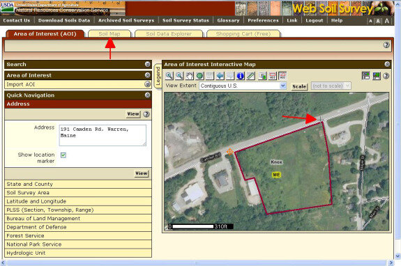
- Interactive Mapping: Users can navigate the map interface to find soil information for specific locations.
- Soil Data Explorer: This feature allows users to access detailed information about soil properties, such as texture, drainage, slope, and erosion potential.
- Suitability Ratings: The Web Soil Survey provides ratings for various land uses, such as agriculture, forestry, and recreation, based on soil properties.
- Reports: Users can generate customized reports that summarize soil information for a specific area of interest.
- Data Download: Soil data can be downloaded in various formats for use in GIS and other software applications.
Benefits of Using the NRCS Web Soil Survey
Utilizing the NRCS Web Soil Survey offers numerous advantages across diverse sectors:
- Informed Decision-Making: Access to detailed soil information enables more informed decisions regarding land use, management practices, and development projects.
- Cost Savings: By providing readily available soil data, the Web Soil Survey can reduce the need for costly on-site soil investigations.
- Environmental Protection: Understanding soil properties can help prevent soil erosion, water pollution, and other environmental problems.
- Agricultural Productivity: Farmers can use soil information to optimize crop selection, irrigation, and fertilization practices, leading to increased yields.
- Construction Planning: Developers can use soil data to assess site suitability for construction, identify potential hazards, and design appropriate foundations.
How to Use the NRCS Web Soil Survey
The NRCS Web Soil Survey is relatively easy to use, even for those with limited experience in soil science or GIS. Here’s a step-by-step guide:
- Access the Web Soil Survey: Open your web browser and go to the official NRCS Web Soil Survey website.
- Navigate to Your Area of Interest: Use the map navigation tools to zoom in to the area you want to investigate. You can search by address, county, or latitude/longitude coordinates.
- Define Your Area of Interest (AOI): Use the AOI tools to draw a polygon or rectangle around the area you are interested in. This will define the area for which you want to retrieve soil information.
- Explore Soil Data: Once you have defined your AOI, you can explore the available soil data using the Soil Data Explorer. This feature allows you to view information about soil properties, suitability ratings, and other characteristics.
- Generate Reports: You can generate customized reports that summarize soil information for your AOI. These reports can be saved as PDF files or printed for future reference.
- Download Data: If you need to use the soil data in GIS or other software applications, you can download it in various formats.
Understanding Soil Data in the Web Soil Survey
The NRCS Web Soil Survey provides a wide range of soil data, including:
- Soil Map Units: These are areas on the map that are dominated by one or more soil types. Each soil map unit is identified by a symbol and a name.
- Soil Components: These are the individual soil types that make up a soil map unit. Each soil component has its own set of properties.
- Soil Properties: These are the physical, chemical, and biological characteristics of the soil, such as texture, drainage, slope, organic matter content, and pH.
- Suitability Ratings: These are ratings that indicate how well a soil is suited for various land uses, such as agriculture, forestry, and recreation.
Understanding these data elements is crucial for interpreting the information provided by the Web Soil Survey and making informed decisions about land management and development. [See also: Understanding Soil Composition for Optimal Plant Growth]
Applications of the NRCS Web Soil Survey
The NRCS Web Soil Survey has a wide range of applications, including:
- Agricultural Planning: Farmers can use soil information to optimize crop selection, irrigation, and fertilization practices.
- Construction Site Assessment: Developers can use soil data to assess site suitability for construction, identify potential hazards, and design appropriate foundations.
- Environmental Planning: Environmental consultants can use soil information to assess the potential impacts of development projects on soil and water resources.
- Land Management: Land managers can use soil data to develop sustainable land management practices that protect soil health and prevent erosion.
- Real Estate Transactions: Prospective buyers can use the Web Soil Survey to evaluate the suitability of land for their intended use.
Limitations of the NRCS Web Soil Survey
While the NRCS Web Soil Survey is a valuable resource, it’s important to be aware of its limitations:
- Scale: The soil maps in the Web Soil Survey are generalized representations of soil patterns. The actual soil conditions at a specific location may vary from what is shown on the map.
- Accuracy: The accuracy of the soil data depends on the quality of the original soil surveys. Some areas may have more detailed and accurate data than others.
- Updates: The Web Soil Survey is updated periodically, but the data may not always reflect the most current conditions.
- Interpretation: Interpreting soil data requires some knowledge of soil science. If you are not familiar with soil terminology and concepts, you may need to consult with a soil scientist or other expert.
It’s always a good idea to supplement the information from the Web Soil Survey with on-site soil investigations, especially for critical applications such as construction site assessment and environmental planning. [See also: Importance of Soil Testing for Accurate Results]
Tips for Using the NRCS Web Soil Survey Effectively
To get the most out of the NRCS Web Soil Survey, consider these tips:
- Start with a Clear Objective: Before you start using the Web Soil Survey, define your goals. What information are you looking for? How will you use the information?
- Explore the Map Interface: Familiarize yourself with the map navigation tools and the various features of the Soil Data Explorer.
- Read the Documentation: The NRCS Web Soil Survey website provides extensive documentation about the data and how to use the tool. Take the time to read the documentation to improve your understanding.
- Consult with Experts: If you have questions or need help interpreting the soil data, consult with a soil scientist or other expert.
- Verify the Data: Always verify the information from the Web Soil Survey with on-site soil investigations, especially for critical applications.
The Future of the NRCS Web Soil Survey
The NRCS Web Soil Survey is constantly evolving as new technologies and data become available. The NRCS is working to improve the accuracy, completeness, and accessibility of the soil data. Future enhancements may include:
- Higher Resolution Soil Maps: The NRCS is working to create higher resolution soil maps that provide more detailed information about soil patterns.
- Improved Data Integration: The NRCS is working to integrate the Web Soil Survey with other data sources, such as climate data and land use data.
- Mobile Applications: The NRCS is developing mobile applications that will allow users to access soil information in the field.
- Enhanced User Interface: The NRCS is working to improve the user interface of the Web Soil Survey to make it easier to use and more intuitive.
Conclusion
The NRCS Web Soil Survey is a valuable tool for anyone who needs information about soil resources. By understanding its features, benefits, and limitations, you can use the Web Soil Survey to make informed decisions about land use, management practices, and development projects. Whether you’re a farmer, landowner, developer, or environmental consultant, the NRCS Web Soil Survey can help you unlock the secrets of the soil and make more sustainable choices. The availability of the NRCS Web Soil Survey data empowers individuals and organizations to make environmentally sound and economically viable decisions related to land use and management. Its continued development and improvement promise even greater utility in the future. Remember to always verify the data and consult with experts when necessary to ensure the accuracy and applicability of the information you obtain from the NRCS Web Soil Survey.
